|
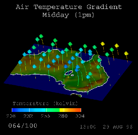
The colours are selected such that that temperatures above
![]() are orange and yellow, temperatures between
are orange and yellow, temperatures between
![]() and
and
![]() are green, and temperatures below
are green, and temperatures below
![]() are blue in colour. This means that the particles ``switch'' colours when
they pass these thresholds, giving good visual indication of what stage of cooling
they are at.
are blue in colour. This means that the particles ``switch'' colours when
they pass these thresholds, giving good visual indication of what stage of cooling
they are at.
Three separate points in time are considered, and an animation is generated for each. The three times are Midday (1pm AEST), Evening (7pm AEST) and Early Morning (4am AEST). It is hoped that these visualisations will exhibit differences since they are from different temperature conditions -- the midday case should be the warmest (at least at ground level), followed by the evening and then the early morning. Unfortunately, this distinction is not as clear as was originally hoped. The midday case was warmer overall, but there is very little difference between the evening and early morning cases. A preliminary attribution for this is the possibility that the results for the evening and early morning cases are skewed because the sun is still shining in the upper atmosphere.
Another noticable feature is how many of the particles have a general drift to the west. This is attributed to the fact that the earth is spinning underneath, and the temperature is the temperature of the air at these points -- hence, this may drift slightly with respect to the earth below.