|
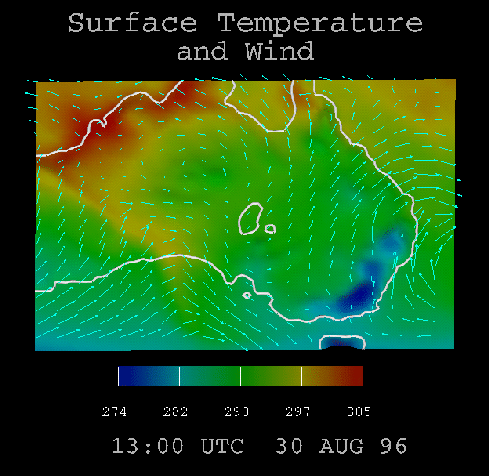
The wind velocity is visualised in the same way as in the first visualisation, described in Section 2.1. The temperature is visualised by colouring the terrain mesh by the temperature of the points in the mesh. This is an easily interpreted way to view temperature data, and also allows the temperature to be directly compared to its geographic location. For example, the blue in the lower right corner of Australia is not surprising when it's geographic location, the Great Dividing Range, is considered.
Another purpose of these first two visualisations is to look for possible correlations between variables, the first between humidity and surface wind velocity, and the second between surface temperature and wind velocity. The most notable example of how successful this technique of combining variables can be is a front progressing from the south western corner of Australia across to the center of South Australia. When analysing the wind vectors alone, this front is quite hard to see. However, when combined with the temperature visualisation, the front becomes very clearly visible, and the unique pattern of wind vectors can be seen above the yellow streak of temperature.
Further, if we then refer back to the first visualisation, clouds can be seen forming over and following the front as it progresses. This kind of clearly visible information and interpretations is the value and reason for combining several variables when visualising.