|
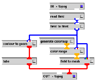
The first section of the network to consider is the topog macro module,
shown in Figure 6. This module reads in the topographic
data and does two things with this data. It converts the topographic field into
a mesh using the given colourmap, giving a mesh which shows the terrain of Australia,
and also takes a contour of the topographic data at the 0.0 value, that is,
sea-level, giving the outline of Australia6. The mesh's ![]() scale is set to 1 to ensure that the terrain is on the
same scale as the rest of the data.
scale is set to 1 to ensure that the terrain is on the
same scale as the rest of the data.
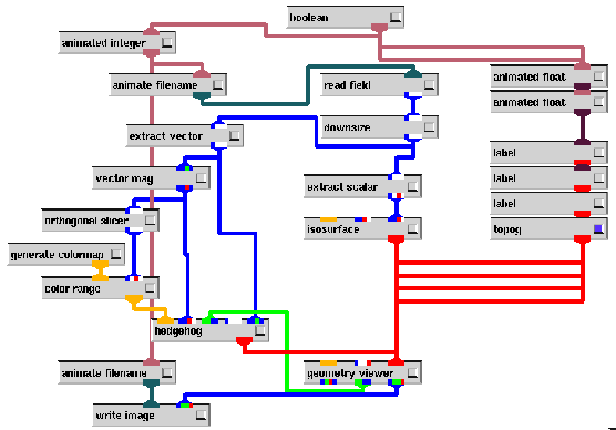
The rest of the network shown in Figure 5 is in several large areas.
The right hand side simply provides context in the output in the form of labels, as well as housing the topog macro module.
The extract scalar and isosurface modules in the middle extract the relative humidity data from the main field, and then display an isosurface of it at 1.0, the dew-point -- these appear as clouds in the output7, as shown in Figure 1.
The modules on the left between the extract vector and hedgehog modules provide the wind vector visualisation, in the form of hedgehog arrows. The arrows are coloured according to their magnitude (and the given colourmap)8, this is the purpose of the vector mag module. The orthogonal slicer module is used to adjust the colourmap to the values of the wind in the lowest slice plane, which is where the hedgehog sample points are located. One problem which arose here is the inability to properly ``thicken'' the hedgehog lines, which will be discussed in Section 4.
Finally, there are several animated integers, floats and filenames to support the reading of the field files and the writing of the image files.
The field files for these networks are constructed in the form mix.xxx.fld, where xxx indicates the timestep sequence, that is, from mix.000.fld to mix.047.fld for this dataset. The field files skip ahead in the data file to wherever their time sequence begins9, and are loaded with the aid of an animated filename module. This method of reading time sequences is easy to construct and is quite useful. The field files were constructed with the aid of a simple awk script. They have several advantages over reading the entire 4D data at once. They don't require as much memory, as they only require AVS to store a single timestep of data at a time, and they are easier to work with when only dealing with a single point in time. However, they have the disadvantage that they are slower when performing an animation, as the early timesteps of the data file must be re-read many times when it is being skipped to read the later timesteps.